Savannah River Kayak Trip

Feb. 21-26, 2004


This year, after pondering the DeLorme state topo maps that I hold near and dear to my heart, I decided to attempt to paddle the Savannah River from Augusta to Savannah. As some of you might remember, I did a similar paddle last year down the Catawba River from Charlotte, NC with the intended goal of Charleston, SC. I actually ended up pulling out, sunburned and weary, at Lake Marion after a bit more than 150 miles.

After researching the Augusta to Savannah trip I actually modified my plans, setting my ultimate goal as Little Tybee Island, an uninhabited island on the coast just past Savannah. The Savannah River was once a major thoroughfare for barges carrying material (most often bricks) from Augusta to Savannah but pretty 
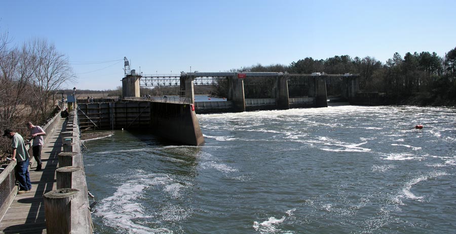
much ceased commercial operations in the early 80’s. A lock system was installed in 1937 to allow river traffic rise up 15 feet to the Augusta waterfront. The lock, dam and river in recent years have been managed and 
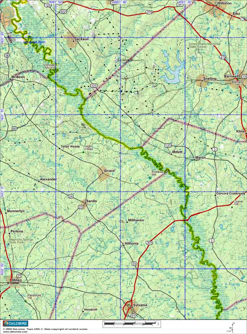
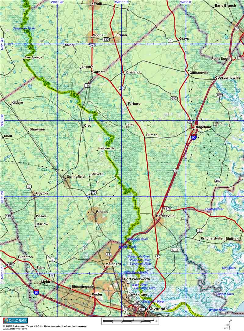
maintained by the U.S. Army Corp of Engineers.

The lock and dam sit adjacent to the regional airport in Augusta and my intended put-in was just below the dam. Since the river system is a navigable waterway, NOAA publishes detailed charts of the entire river and according to the Corp of Engineers measurements it is exactly 200 miles from downtown Augusta to the mouth of the Savannah River.

The plan is to put in just below the dam and paddle for an undetermined number of days down to Little Tybee Island. I was hoping for a nice, low water level with idyllic sandbars to camp on, in contrast with my flood stage trip down the Catawba. In the weeks leading up to the trip I kept an eye on the USGS river gauges and judged the river to be at a stable and predictable level with plenty of dry land on the immediate banks.

The two overall maps of the river the left map is the upper half the right map is the lower half.  As a distance reference, the entire scale at the bottom of the map is 20 miles in length.


(click on all images to expand them!)

On February 21, I drove down to Augusta with all of my gear to spend the night at the Augusta Radisson on the riverfront in downtown Augusta. Marisa flew in that afternoon to drive the truck back to Charlotte since I would be doing this trip solo. We spent Saturday walking around the very nice riverfront area of Augusta and had a great dinner. The area is very beautiful but seems to be struggling. Many shops were shuttered and many spaces were vacant, although many of the businesses I suspect are seasonal.

Before picking up Marisa at the airport I took a drive down to the lock and dam and took a few pictures. The water level appeared right where I expected it and the weather was warm and sunny in the upper 60s.

The view from below the lock and dam, the lock itself is on the left side of the picture:


An engraving in the stone walkway along the riverfront in downtown Augusta:

After spending a wonderful (luxurious!) night in the Augusta Radisson we drove down to the put-in below the dam on Sunday morning (Feb. 22). Imagine my surprise when we rounded the corner and I saw the boat-ramp was almost completely submerged! What the hell is going on??! A bit alarmed at the new and unexpected development I watched as the river surged up tight against it’s banks, the muddy water swirling, bubbling, roiling away downstream. My hopes for huge, beautiful white sandbars quickly vanished 
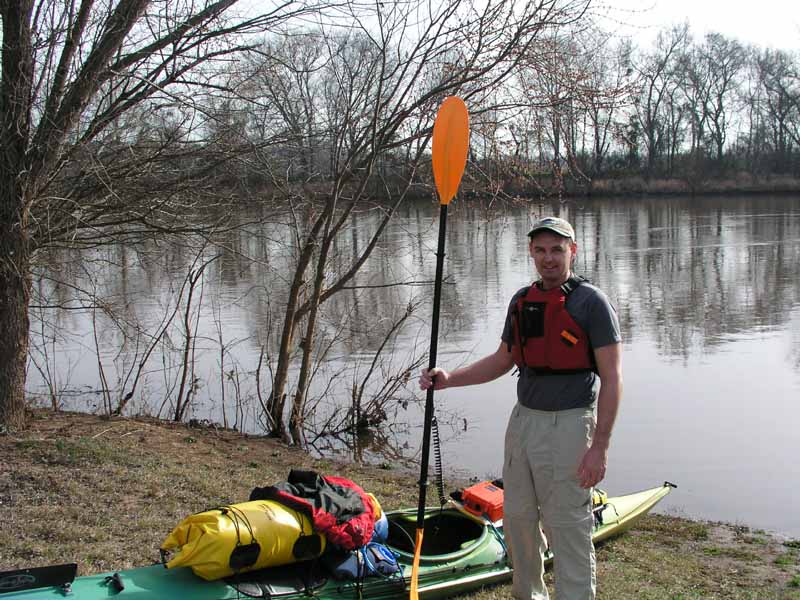
as I started loading my boat for the trip.

With no real expectation on how long the trip was going to take, I planned on at least 8 days on the river. As such, I took a crazy amount of supplies. I had also vowed to eat well on this trip taking hamburger, chicken, and pork all frozen in a small cooler. The biggest space and weight penalty was the 5+ gallons of water I was carrying.

The Savannah River Site (SRS), owned by the Department of Energy, bounds one bank of the river for a good 30 miles or so. SRS is a relatively spooky (like CIA spooky) area where a lot of nuclear weapons research, development and fabrication occurred. According to reports there are literally millions of gallons of heavy metal contaminated water being stored on the site while clean-up is underway. With the Savannah River being one of the more suspect rivers with regards to water quality, I figured filtering water was out of the question, so the penalty was having to tote along with me a ton of water, which took up a lot of below-deck space and the added weight really brought the waterline up high on my kayak.

Other items included the standard camping fare: clothes, food, snacks, sleeping bag, sleeping pad, small tent, cooking supplies, GPS, etc..etc.. The light, yet bulky items such as the tent and sleeping bag, I stored in dry bags mounted on the decks. The heaviest items (water) I put in the bottom of the boat to keep the center of gravity low. Directly in front of the cockpit were direct access items such as maps, camera, video-camera, spare batteries and a small assortment of cookies and crackers to eat while paddling. In any case, after the boat was completely loaded it looked like a real tramp steamer:
 

Saying good-bye to Marisa I pushed off the bank late in the morning on Sunday and pointed down-river. The current was giving me a free push of about 2 mph for almost the entire duration of the trip. Coupled with my “cruising stroke” I was averaging about 5.5 to 6 mph.
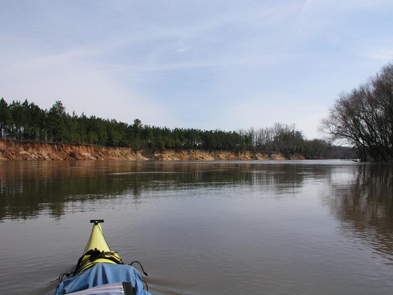
The first thing I was surprised by was how BIG the Savannah River is. I really had no idea that it was such a wide river until I was on it. Granted, the water volume was high, but I was impressed and a little disappointed that the river wasn’t more “cozy”. For hours I paddled, debating the relative merits of staying on the inside of the river bends or the outside. You see, if you stay on the outside of the river bends, the majority of the current lies there, so you probably gain an extra ½ to 1 mile an hour, however, you are also paddling a further distance, so at what point is it better (particularly on a wide river) to “cut the corner” or take the free ride? I never did really reach a conclusion as to which was the better option. The other drawback, of course, to riding the outside bends of the river is that the current rushed much more quickly through the “strainers” on the outside bends (to the non-paddlers a strainer is something like a tree down in the river, the branches of which tend to collect things, like wayward kayaks, and pin them leading to “very bad things”).
 

Many of the bends in the river were bounded by large bluffs, much more so than on the Catawba River:

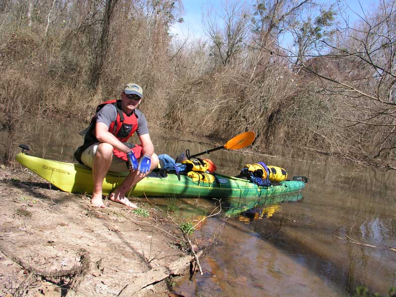
After several hours of paddling I pulled out on a small sand/mud bar to take a bathroom break and stretch my legs. The paddling was going very well and with such fine weather I was really enjoying watching all the scenery go by:

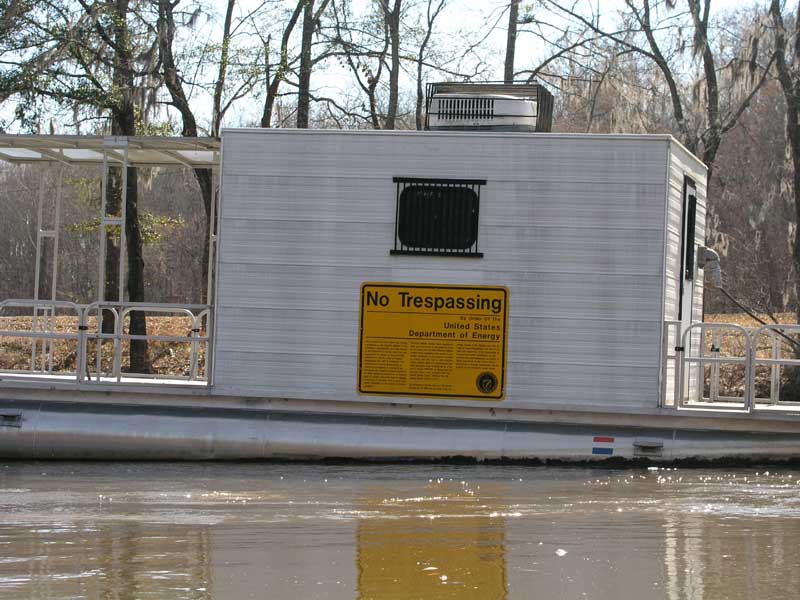
In a couple more hours I was upon the boundaries of the Savannah River Site (SRS). Every hundred meters or so a large yellow sign proclaimed that the Department of Energy would arrest you, charge you with a felony, and place you in leg irons if you dared step upon their land. In addition there were many of these floating pontoon boats anchored in the river at various spots. My guess is they are monitoring radiation or contaminants leeching into the river from SRS property. In any case, the whole area has a very “the black helicopters are watching you” feel to it.

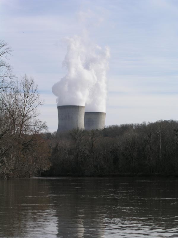
The SRS site, which is totally off limits, bounds the river on the left (east) bank so I was a bit surprised when I soon started seeing signs on the right (west) bank stating “No Trespassing – Armed Security Units Patrolling Property”. I had no idea what would prompt that until I rounded a bend and spied a nuclear power plant cooling tower. This was a civilian nuclear plant though, not government.

It was getting toward mid-afternoon now and as soon as the nuclear power plant property ended, I landed at the next available public boat ramp for a stretch. Not more than 60 seconds after my boat hit the shore-line a white 4-wheel drive vehicle pulled up and out hopped a SWAT looking security guard with all kinds of radios and weapons and other cool GI Joe paraphernalia hanging from his various harnesses. As he walked toward me he clenched his hand microphone mounted on his left shoulder and whispered something like “Alpha unit one, River Wolf Two-Zero, the coyote is in the hen house, the coyote is in the hen house..over..” Just kidding..I think 
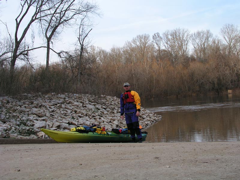
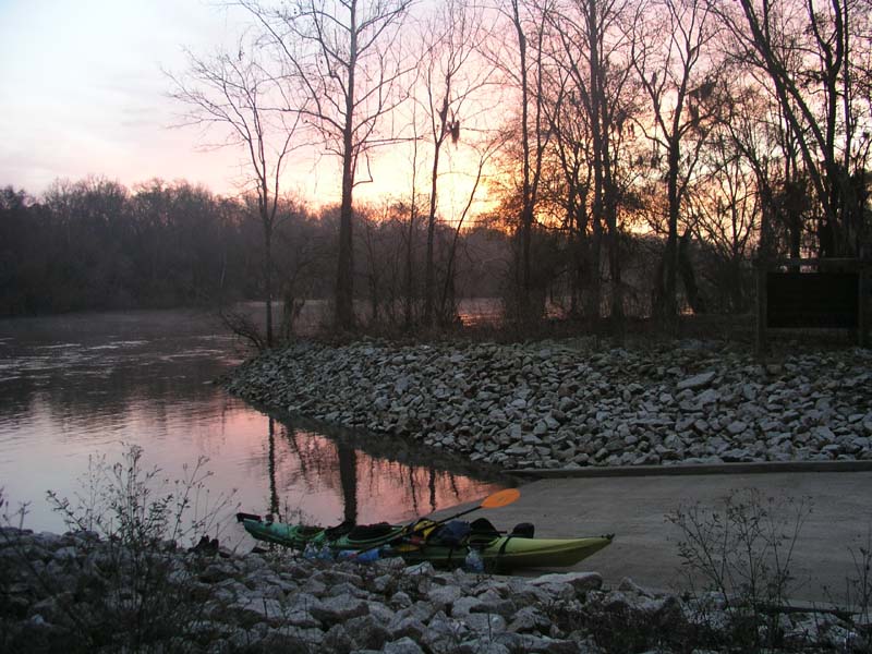
he said something like “Joe..I’ll be off the frequency for a minute..”

In any case, I was subjected to what I would call a friendly interview about who I was, where I came from, and where I was going. My guess is that somewhere on the river they have surveillance cameras mounted in the woods to keep tabs on people moving up and down the river. Once the security guard determined I wasn’t a terrorist he offered up some good suggestions on camping further down the river. I took the opportunity to don my dry-suit since the temperature was falling and I knew it was always a good idea to have it on in the late afternoon in case I got stuck out on the river in the dark and ended up taking an accidental swim.

I put back onto the river and a couple hours later, as the last daylight waned, I found the public boat ramp the security guard had hinted would be a good spot to camp, Brigham’s Landing, about 12 miles north-east of Girard, GA. It was out in the middle of nowhere and had a nice flat, dry area to setup camp.


All told for Day 1 I managed 40.86 miles, averaging 5.3 mph and a max speed of 7.7 mph. The campsite was located at N33 05.8 / W81 39.2 I pulled my kayak up the boat ramp a bit and started unloading all of my gear to make camp. I noticed a small pick-up truck parked near the road leading away from the ramp, but all was quiet in the woods. After setting up camp I made a delicious dinner of cubed pork, coated in Shake & Bake which I lightly fried in my miniature Dutch oven. It was probably one of the best camping meals I’ve ever made.

As I was settling in to eat it was pretty much full on dark and there were a million stars out. The temperature was dropping fast but I had changed into warm fleece clothes and was just sitting by my campfire eating when all of the sudden a deafening gunshot rang out from the woods not far from my camp. Jesus I must have jumped out of my skin. A few minutes later I heard 5 more tightly spaced shots come echoing out of the woods and for a minute I worried a stray round might come whizzing through my camp site. About 5 minutes later a guy emerged from the woods and I said “hello”. I’m sure he was pretty surprised to see me there all camped out and he came over and we talked for awhile. He was very interested in the trip and the kayak. When I asked him what he was hunting he replied that he was just out “harassing squirrels”. He was a nice guy and told me I should be pretty comfortable there that night since nobody would come way out there by the river at night.
 

Click here to continue...