|
He took off but imagine my surprise when an hour later another truck came
roaring down the road through the woods. It started to turn around in the
small parking area, down rolled the window and a lady yelled out “You
ok??” I stated that I was fine and that I was camping out on my way down
the river. She said she was just checking and didn’t want anyone stuck out
there in the woods all night, then off she roared back into the woods.
My phone didn’t really work and just barely got an analog signal. I called
Marisa to let her know I was fine, but the signal was so bad that she
couldn’t hear anything I was saying. Finally I got her on the line for
about 15 seconds I just said over and over again “I’m OK, I’m OK, I’m OK…”
hoping that one of them would get through. She finally heard one of them
and I turned in for the night.
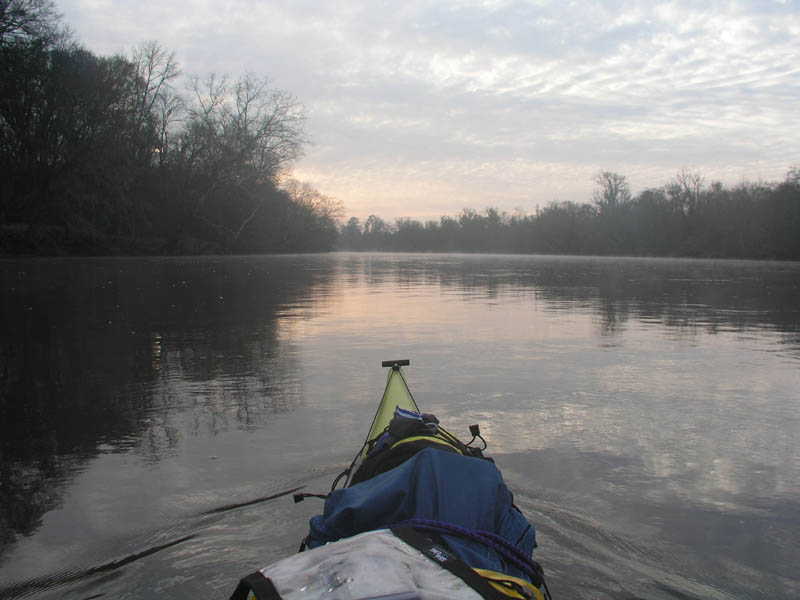
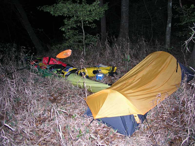
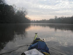
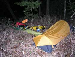
Day 2 broke clear and cool with just a little mist rising from the river.
I quickly broke camp and packed up my kayak and hit the river around 0730.
As I paddled down the river I could see many white-tail deer jumping
through the woods on my left as I splashed my way downriver. I also saw an
occasional river otter or muskrat swimming across the current.
All along the river were little calm tributaries leading off into the
woods. They would have been fun to explore, but with my 17’ long kayak I
was pretty sure I wouldn’t be able to easily turn around in them.
I paddled steadily all morning and stopped a Johnson’s Landing at around
1110 to stretch my legs and eat some cheese and crackers for lunch.
At about 1215 I started
hearing the sounds of auto traffic and at 1230 passed under the Highway
301 bridge.
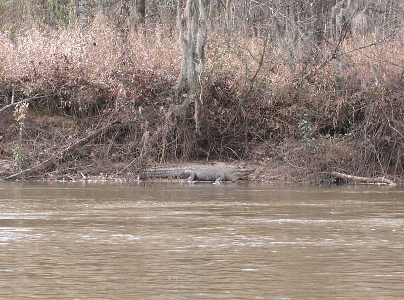
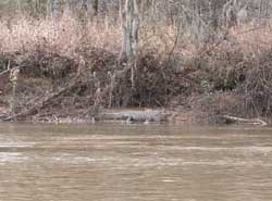
Shortly after passing the 301 bridge I had a relatively big surprise when
I paddled around a bend and casually looked to my right and spied a medium
sized alligator sunning himself on the bank. For a second I actually
thought he was made out of plastic! Though I knew alligators were likely
in the area, I figured in late February there would be no chance of seeing
any since the water and air were still so cold. Apparently, as I read
after the trip, alligators are not a true hibernating species. They will
sun themselves if the weather is warm enough at any opportunity! I passed
several more alligators on my way down the river, at one point there were
four clustered on the same mud-bar.
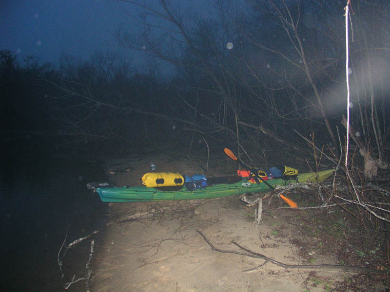
As daylight faded I started searching for a good camp-site and came upon a
bend with a nice looking sandbar. I pulled up onto it and though I knew it
was irrational, I always kept a wary eye on the shallow water waiting for
an alligator to come springing out of it like you see on the Discovery
Channel! Logically I knew that with the water was so cold the alligators
would likely be extremely sluggish and not interested whatsoever in
something as big as a person, but it was always there in the back of my
mind.
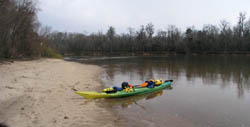
Day 2 total mileage was an impressive 52.4 miles, averaging 5.4 mph. The
camp-site was located due east of Sylvania, GA at N32 43.9 / W81 25.7
I made camp at the top of the sandbar, built a fire and started preparing
my meal. This time I had a really good meal of browned ground beef, taco
seasoning, a can of Rotel tomatoes all mixed together and topped with some
shredded cheese. I used nacho chips to scoop it out. Though it was really
good I didn’t have much of an appetite because as I was making dinner I
started to get a bit anxious about the fact that the water was rising.
When I initially landed on the sandbar, I stuck a stick in the sand at the
waters edge to gauge whether the river was rising or falling. I was a bit
alarmed after making camp to see the water was already surrounding the
stick. Over time I estimated the water was coming up about 2 inches an
hour and figured that by day-break I would still have some sandbar left,
but that was assuming the rate of rise didn’t increase in the middle of
the night.
Little things like that, when you are alone, in the middle of the woods
tend to nag at you all night. I have a tendency to over imagine as I’m
laying there in my tent and my mind started racing with thoughts of the
water entering my tent in the middle of the night. I was able to get a
cell phone signal and talked to Marisa for about 20 minutes, which was
really nice. In lieu of having a partner along for these trips a cell
phone is a close second.
I kept my dry-suit nearby and had the kayak totally loaded and prepared to
hit the water in case the water level started a dramatic and rapid rise. I
could barely sleep and in the middle of the night a light rain began to
fall. I constantly kept unzipping my tent flap to peer out into the
darkness with my headlamp to see how far up the water had come. In
addition, every time I opened the tent flap I half expected to see the
beady red eyes of an alligator staring back at me from the 3 or 4 feet
that separated my tent from the rising water. It was a sleepless night.
When my alarm went off shortly before sun-up, I broke down camp and saw
the water had risen significantly, but I still had a tenuous patch of sand
left.

On the
water very early on Day 3 I was paddling through constant rain. My
sleeping bag, pad and tent were all a bit damp from the night before, so I
was dreading making camp later that night. I paddled hard all day eating
lunch on the water and stopping for a mid-day stretch at Stokes Bluff
Landing to stretch my legs.

Judging my pace on the map I was confident that I could make I-95 by
evening. The continuous rain was really a downer though and the grey light
made the woods, sky and river all the look the same color.
About 10 miles north of Hardeeville I heard a lot of noise and excitedly
thought I was coming up on the I-95 bridge. After a few bends in the river
though a huge factory loomed into view and I realized that was the source
of all the machinery noise.
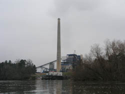
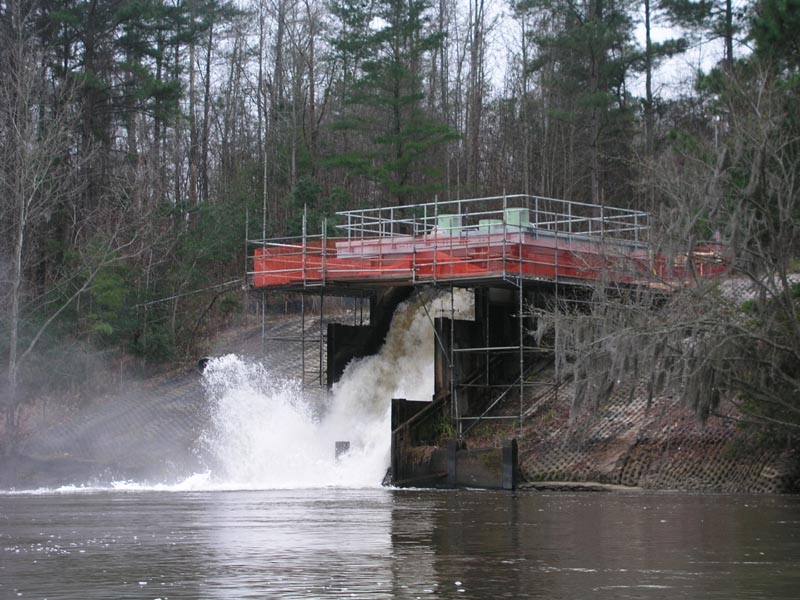
From one side of the factory this huge outlet was pouring thousands of
gallons a minute of water into the river. I really didn’t want to know
what was being added to the river at this point. I figured I probably
already had enough nuclear waste exposure downstream of the SRS site that
a little more wouldn’t matter!
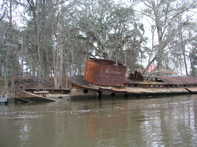
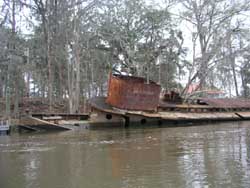
Rounding a few more bends near Hardeeville there were several old wrecked
river boats laying along the river banks. The iron ones were still fairly
well intact while the wooden hulled ships left only skeletal frame and rib
remains behind.
Again I had made the mistake of staying on the river too long and soon I
was running out of options for camping. I passed a beautiful boat landing
at Hardeeville, but when I got out of my boat there were signs all over
the landing stating that overnight camping was strictly prohibited.
Getting back into my kayak I headed downriver and within a couple miles
realized I was in a bit of trouble. South of Hardeeville the river starts
to be affected by the Atlantic’s tidal range. The tidal range starts just
north of Hardeeville and goes from only a few inches to nearly 7 to 8 feet
at the mouth of the Savannah River.
As I paddled down the river I noticed my speed increasing up to 7.5 mph on
the GPS and I knew what was happening. All of the tidal areas and
marsh-land in the lower tidal zone was dumping out into the river on the
falling tide. In addition to a roaring current along the banks I was faced
with high banks on both sides that I’d have to scale in order to reach dry
land.
With daylight fading fast I tried first one, then another spot trying to
find a good camp site. Rounding another bend I made out a relatively high
and dry site and knew I was out of options. Driving the nose of the kayak
up onto the mud shelf I braced my paddle into the mud and pulled with all
my might to get the stern parallel to the shore against the pull of the
current. Stepping carefully out of my kayak I sunk almost to my knees in
the black muck of the marsh mud. Nice.
I slogged my way up the bank dragging my kayak with me through the mud.
Now the dilemma was how to get the kayak up the 4 foot bluff onto dry
land. I tried to prop the bow up on the bluff but the weight of the boat
just caused the whole boat to slide back down the mud bank toward the
water. I was forced to take all of my gear out of my boat and toss it over
the bluff into a pile before the boat was light enough to lift onto the
bank. Exhausted, wet, muddy and not really happy with the decisions I made
this afternoon I started setting up my tent.
|
|
I was actually camping illegally since the area was a National Wildlife
Refuge, but with no other option available I lived with the guilt. I
didn’t make a camp-fire and elected to just wolf down some dry foods
instead. The tidal current really freaked me out a bit and I decided that
since I was only about a mile from I-95 I was pretty much in Savannah. I
didn’t feel confident, or more correctly comfortable, with challenging the
tidal races tomorrow through the shipping area of the port so I called
Marisa hoping she would be able to pick me up the next day back upriver at
the beautiful Hardeeville landing I had passed earlier.
Day 3 was a whopper with 57.5 miles total ending up just a mile short of
where the I-95 bridge crosses the river into Savannah. Though I was
disappointed that I didn’t have the confidence to continue through the
port to Tybee Island, (arguably the prettiest part of the trip!) I was
happy to have made it to Savannah in just 3 days!
I took a couple Tylenol PMs to ward off the aches and help me get to sleep
and turned in. I slept like a rock and the rain tapered off into the
evening and was replaced by cold, breezy conditions.
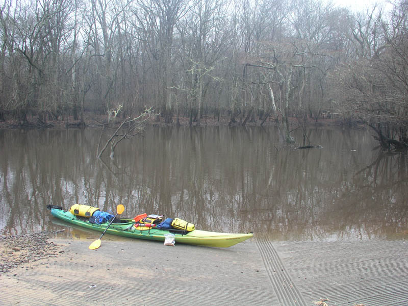
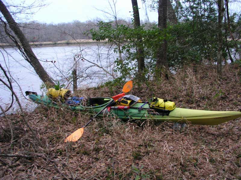
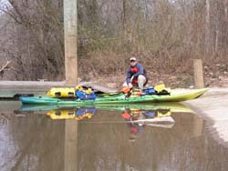
I awoke early the next morning intending to paddle back upstream the 4
miles or so to the Hardeeville landing. The tide was approaching dead low
but I knew I was going to be in for a hard paddle upstream against the
current. I loaded the boat on the dry ground of camp and gently lowered it
over the bluff onto the muddy bank below taking care not to let it slip
all the way into the current. I tried to rinse as much of the mud off my
booties as I could before stepping into the cockpit then gave a push and
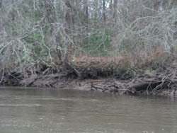
slid down the muddy slope into the water.
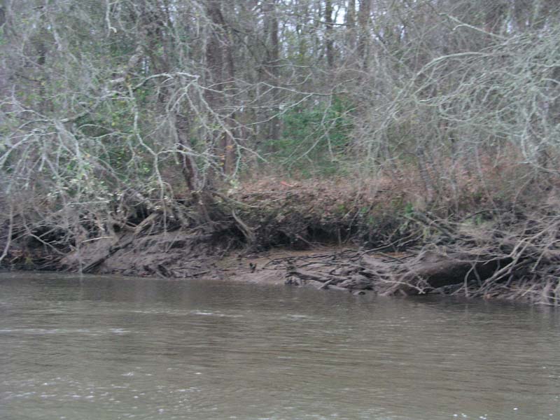
This picture shows the muddy bank and the bluff I had to push my boat up
the previous night.
Once on the water I paddled hard back up-river. By staying close to the
banks and on the insides of the bends I was able to make about 2 mph
upstream. At one point though the combined river current and the tail end
of the slacking tide held me a 0 mph for a few minutes until I could ferry
over to the other side of the river and make some progress up an eddy
behind a wrecked river boat on the bank.
After about 2 hours I made it the 4 miles back up-river to the Hardeeville
boat landing where I gratefully pulled out and started unloading.
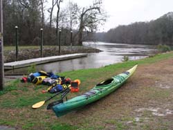
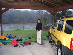
On one
side of the landing was a concrete pad with a shelter above it so I
transferred all my gear under it and out of the rain to await my ride.
Marisa couldn’t leave work in Charlotte until around noon and it was
almost a 4 hour drive down to pick me up, so I knew I had a bit of time on
my hands. I peeled off my dry-suit and put on several layers of clean,
warm clothes and laid down on my sleeping pad to read while I waited for
her. As the day progressed the temperature dropped rapidly from the high
50s down to the low 40s.
At mid-afternoon Marisa was well on her way down the road to get me and
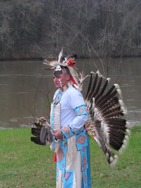
suddenly about 5 or 6 cars, including a police car, pulled into the until
now deserted access area. Out hopped a few people and some cameras and a
man came up to me and introduced himself as the man in charge of
development for the city of Hardeeville (Rob Dewig). He told me they were
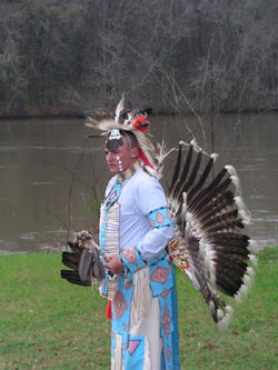
having a press conference and demonstration for the news about an Indian
Pow-Wow being held a couple weeks from now. They were all really
interested about my trip down the river and eventually native American guy
named Joe, a Marine stationed on Parris Island, pulled up to give an
amazing demonstration of native American dancing. It was a bizarre ending
to a strange trip.
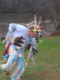
After the dance and some interviews, the whole crowd disappeared as fast
as they came and I was once again alone. A couple hours later in the
fading light Marisa showed up to whisk me home (with the obligatory stop
at Burger King on the way). It was great to see her again and be back in
the comfort of all things known.
It turns out that it was a good thing I got off the river on the 4th day
(Wednesday) since South and North Carolina were hit with record snow-falls
the next two days. I was happy to be at home looking out at 16 inches of
snow instead of being stuck down on Tybee Island in the cold rain!
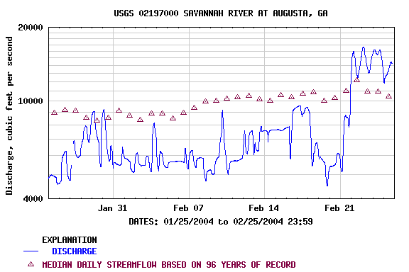
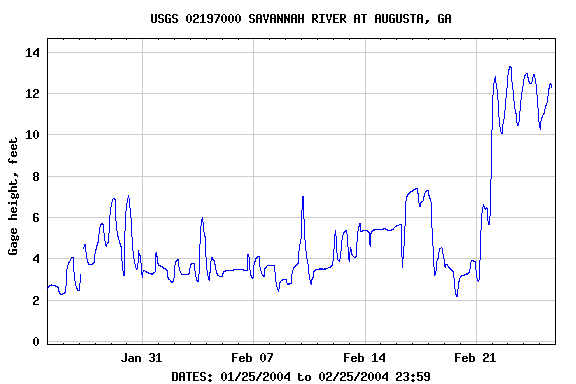
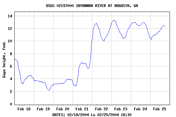
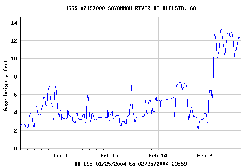
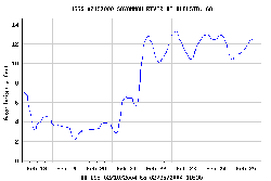
Upon returning home I went back onto the USGS web-site to investigate what
had happened to the river levels. Imagine my surprise when I saw the
graphs denoting the river level. The day I arrived in Augusta was just
like the previous month, low river levels with small variations in volume
and height. On Saturday night, as we lay sleeping in our hotel, the dams
up-river must have opened up wide because the water level jumped from
8,000 CFS to to over 16,000 CFS in just the span of a couple hours!
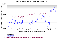
The resulting surge raised the river level gauge from an average of about
4 feet to over 12 feet! Had I been on a sandbar in the middle of the river
24 hours earlier, there is a good chance I would have been washed off in
the middle of the night!
In any case it would have been nice to have a lower river level for the
trip, but the unknown is part of the excitement and challenge of any trip.
I always list some lessons learned from each long trip even though I end
up forgetting them by the next one.
1. Bring a friend. As usual, being alone sort of sucks on the river. It’s
safer and I think more fun to have someone along.
2. Pack lighter. I packed enough stuff to last basically 8 days because I
didn’t know if I’d be able to do 25 miles or 50 a day. Sometimes I think
it would be better to pack less and have to stretch it than pack way too
much and be burdened by excess weight and bulk.
3. Seam seal your tent. I had only used this tent once before and it
hadn’t rained on it yet. I found some leaks in the rain-fly this time,
resulting in a wet sleeping bag.
4. Have a pull-out time. Marisa actually came up with this one after
hearing me complain how difficult the last hour on the river was each
night. Break the crazy cycle of pushing for mileage by setting a definite
cut-off time on the river. At 4PM for instance, say that you will take the
first attractive campsite you come across instead of waiting until the
fading light at 6PM and you are frantically searching for anything at that
point.
5. Be aware of how tides can affect both camp-site selection and paddling
distance. I underestimated the power of the tidal range. In the summer
when you might have 15 hours of daylight to work with I think you have a
lot more options available since you can effectively catch 2 tides at a
time going your way. In the winter, you are often limited to one.
6. Keep in mind that water levels on rivers below reservoirs can change
rapidly. Most of the big reservoirs I know of in the Carolinas have no
planned or regular release schedule so you might be standing high and dry
one minute and wading the next.
7. Buy and use a dry-suit. Even though the weather never got below the
mid-40s the water coming out of the mountains was very, very cold. The
comfort of paddling in the cold rain while wearing fleece and staying dry
was awesome. And the confidence to know that if you did take a spill into
the cold water you would have plenty of time to work on self rescue was
worth every penny. My brand new Gore-Tex Kokatat Dura was the best money
I’ve ever spent on paddling. (Get the relief zipper and socks!)
8. Pick an intimate river instead of a big clunker like I did. The
Savannah was not an ideal paddling river. It was just too big, broad and
deep. The wildlife was nice, but the topography was pretty limited. I
still long for a nice Class I river with crystal clear water, pebble and
sand beach sand-bars and beautiful scenery. I might need to head north or
west in order to find those ideals. I’ve seen enough mud for now.
That’s about it. In my Catawba River trip I learned like 30 new things, so
I guess I picked up a thing or two back then. If you have any questions,
comments or suggestions, feel free to drop me an e-mail.
Return to our Main Page....
 |